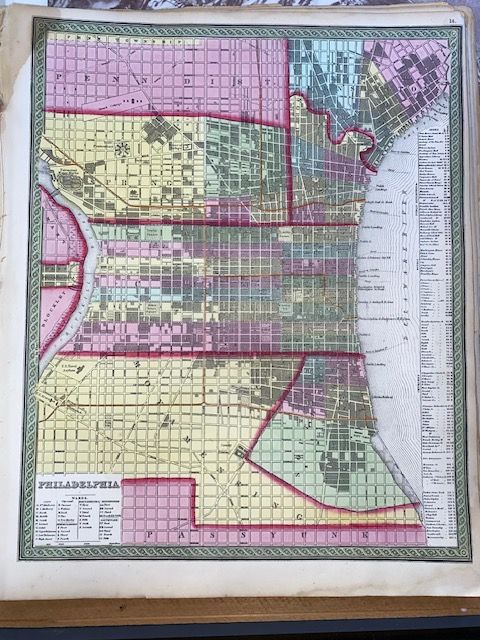
Rare Original 1854 Mitchell Map of Philadelphia
$150
Price incl. GST (15%) $19.57
In stock: 1 available
Product details
An original 1854 Mitchell Map of Philadelphia is a highly collectible and significant piece of mid-19th-century American cartography. Created during a transitional period in American publishing, this specific map captures Philadelphia just as it was undergoing massive urban growth and structural transformation.
Historical Context & Production
-
The Cartographer: Samuel Augustus Mitchell was one of the most prominent American map publishers of the 1800s. Originally a school teacher frustrated by the poor quality of school geography texts, he relocated to Philadelphia in 1821 and established a massive map-publishing empire.
-
The Publisher: Although bearing Mitchell's name and style, the 1854 edition was published by Thomas, Cowperthwait & Co.. Mitchell had sold or partnered his printing plates to this Philadelphia-based firm in 1849, which continued updating and issuing his acclaimed Universal Atlas.
-
The Technique: Mitchell maps are famous for pioneering steel-plate engraving (moving away from softer copper plates). This allowed for incredibly sharp, fine lines that could withstand large printing runs without losing clarity.
Map Characteristics & Visual Details
-
Hand-Coloring: Authentic originals feature vibrant, distinctive hand-colouring used to differentiate city wards, districts, and adjacent areas (like Camden, New Jersey).
-
The Border: A hallmark of Mitchell/Cowperthwait maps from this specific era is the elaborate, interlocking vine or floral border that frames the engraving.
-
Scope: The 1854 street layout generally captures the core of the city, typically extending north toward Columbia Avenue and south to Jackson Street, showing the grid system, early rail lines, and shipping wharves along the Delaware River
-
Printed Area (Image Size): Approximately 12.5 x 15.5 inches (31.8 x 39.4 cm). This is the exact measurement of the engraved map details and its interlocking vine border.
-
Full Sheet Size (including margins): Approximately 13 x 16 inches to 14 x 17.25 inches (33 x 40.6 cm to 35.6 x 43.8 cm)
-
Excellent condition
Rare Original 1854 Mitchell Map of Philadelphia
Display prices in:NZD