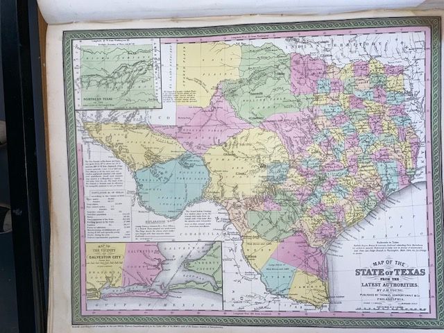
Rare 1854 Mitchell "Map of Texas"
$350
Price incl. GST (15%) $45.65
In stock: 1 available
Product details
The rare 1854 Mitchell "Map of Texas" (officially titled "Map of the State of Texas from the Latest Authorities") is one of the most historically significant and visually distinct atlas maps of Texas from the mid-19th century.
Drawn by J.H. Young and published in Philadelphia by Thomas Cowperthwait & Co. for Mitchell’s New General Atlas, this map captures Texas during a crucial period of geographical transformation.
🗺️ Key Cartographic & Historical Features
-
The Post-Compromise Boundaries: This map is highly notable because it reflects the finalised northern and western borders of Texas. Following the Compromise of 1850, Texas surrendered its expansive claims to eastern New Mexico and the upper Rio Grande in exchange for the federal government assuming its public debt. The map establishes the northern panhandle boundary at latitude 36°30'.
-
The Northern Panhandle Inset: Because the newly defined state was so massive, the northern panhandle was separated and presented via a distinct inset map in the upper-left quadrant.
-
Galveston Inset: A detailed lower-left inset illustrates the vital shipping hub of Galveston City and its vicinity.
-
Frontier Details & Routes: The map is richly detailed with annotations critical to 19th-century pioneers, military personnel, and traders. It highlights Apache and Comanche companion trails, notes the navigability of the Rio Grande, traces early and proposed railroad lines, and marks geographical anomalies like El Llano Estacado (the Staked Plains).
-
The Rare 1854 Variant: While the standard 1854 edition is heavily sought after, an incredibly rare variant issue exists from the same year. This specific variant introduces Hidalgo County along the Mexican border and sketches the proposed route of the Atlantic and Pacific Railroad slicing completely across the state—details missing from earlier 1854 printings.
🎨 Aesthetic Style
True to the signature production value of Samuel Augustus Mitchell, the map features an intricate, separately engraved floral border and vibrant pastel hand-colouring to differentiate counties.
Topography is meticulously rendered using hachures (short parallel lines indicating shade and slope steepness).
Rare 1854 Mitchell "Map of Texas"
Display prices in:NZD