Original 1854 Mitchell "A New Map of South Carolina"
$200
Price incl. GST (15%) $26.09
In stock: 1 available
Product details
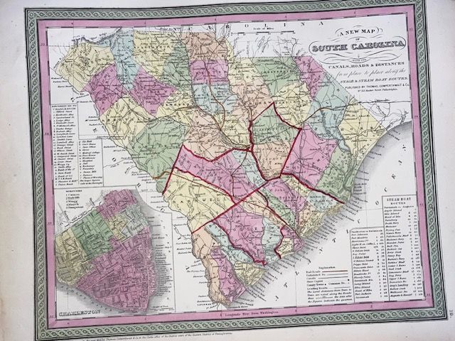
The Original 1854 Mitchell "A New Map of South Carolina" is an important pre-Civil War map published by Thomas, Cowperthwait & Co. in Philadelphia. Celebrated for its rich hand-coloured engraving, distinctive green scrollwork borders, and immense practical data, this artifact offers a fascinating snapshot of mid-19th-century American transport and travel
Key Historical & Cartographic Features
-
Comprehensive Transport Network: The map functions as a mid-century travel guide, detailing active roads, ferries, canals (such as the blue-highlighted Santee Canal), and rapidly expanding early railroad routes marked in red.
-
Charleston Borough Inset: The bottom-left quadrant features a highly detailed inset plan of Charleston. It explicitly breaks the city down into its five historic boroughs: Cannon, Radcliffe, Wragg, Mazyck, and Hampstead.
-
Reference & Distance Tables: Key boxes catalog over three dozen vital city streets, wharves, and landmarks alongside meticulous tables showing steamboat and stage distances from town to town.
-
The 1850 Imprint Anomaly: Collectors frequently note that while published in the 1854 edition of Mitchell’s New Universal Atlas (Plate 19), original prints often retain the earlier copyright imprint line: "Entered according to Act of Congress in the year 1850 by Thomas Cowperthwait and Co.". This stems from publishers using the same copper plate over subsequent atlas updates without altering the base copyright engraving.
Cartographic Heritage
The map's underlying geography is built upon the foundational work of legendary cartographer Henry Schenck Tanner, heavily augmented and styled by Samuel Augustus Mitchell's studio with their iconic color palettes and border motifs
Original 1854 Mitchell "A New Map of South Carolina"
Display prices in:NZD