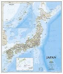
Japan Wall Map · Nat Geo
$52.17
Finish
Please choose
In stock: 1 available
Product details
The signature Classic style map of Japan offers a visually stunning and detailed representation of the country. Here’s what makes this map exceptional:
- 64cm x 75cm
- Bright colour palette: Featuring blue oceans and terrain depicted in shaded relief, a hallmark of National Geographic wall maps for over 75 years.
- Detailed content:
- Thousands of place names.
- Accurate boundaries.
- National parks.
- Major infrastructure networks, including roads, highways, airports, and railroads.
- Coastal bathymetry: Depth curves and soundings enhance the map’s oceanic details.
- Inset maps: Provides additional detail for Japan’s Southern Outer Islands and the Ryukyu Islands.
- Historical information: Includes data about the 2011 Tohoku earthquake and tsunami.
Japan Wall Map · Nat Geo
Display prices in:NZD
