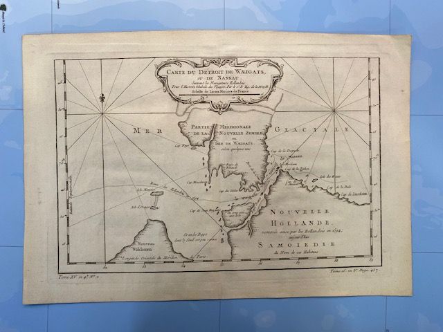
18th Century Original Map - Carte du Détroit de Waigats ou de Nassau
$150
Price incl. GST (15%) $19.57
In stock: 1 available
Product details
"Carte du Détroit de Waigats ou de Nassau"
The "Carte du Détroit de Waigats ou de Nassau" (Map of the Strait of Waigats or Nassau) is a renowned 18th-century historical maritime map. It portrays the Arctic strait now known as the Yugorsky Strait, which lies between Vaygach Island and the Russian mainland.
Key Features:
- Antique Craftsmanship: This map is an exquisite copperplate engraving created by the distinguished French hydrographer Jacques-Nicolas Bellin.
- Historical Significance: It was published around 1758–1759 as part of the monumental Histoire Générale des Voyages (General History of Voyages) by the Abbé Prévost.
- Geographical Insight: The map documents early European efforts to discover the Northeast Passage to India and China, confirming that the Novaya Zemlya archipelago is entirely separate from the mainland.
Historical Context:
-
Origin of the Names:
- Waigats derives from the name of the Russian island, Vaygach.
- The alternative name, Strait of Nassau, was bestowed by the Dutch navigator Willem Barentsz and his crew during their 1594 expedition. This name honors Maurice of Nassau, Prince of Orange.
-
The Cartographer:
- Jacques-Nicolas Bellin (1703–1772), a preeminent French Marine engineer and the official hydrographer to King Louis XV, meticulously designed this map.
-
Geographical Importance:
- The map captures the early European attempts to chart the Arctic and explore potential trade routes. It stands as a testament to the efforts to locate the Northeast Passage, highlighting the separation of the Novaya Zemlya archipelago from the mainland.
This historical artifact stands as a remarkable representation of 18th-century maritime exploration and cartographic excellence.
36cm x 25 cm - In excellent condtion with no foxing, water stains or damage to paper
18th Century Original Map - Carte du Détroit de Waigats ou de Nassau
Display prices in:NZD
