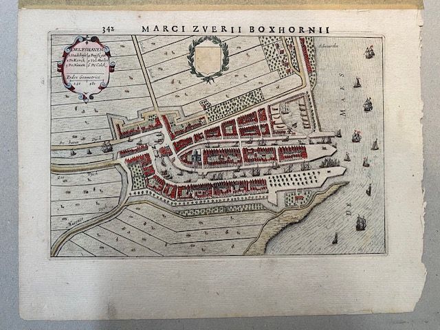
1649 Map - Delfshaven by Joan Blaeu
$350
Price incl. GST (15%) $45.65
In stock: 1 available
Product details
A beautiful map from a famous 17th-century Dutch chorography atlas by the Dutch scholar Marcus Zuerius van Boxhorn (Latinised as Marci Zuerii Boxhornnii).
The reference points directly to page 342 (or the text facing the map) of Boxhorn's highly acclaimed work, Tonneel, ofte Beschryvinge des Lants en Steden van Hollandt ende West-Vrieslandt (Theatre or Description of the Lands and Cities of Holland and West Friesland). This work was initially published by Hendrik Hondius in 1632 and later expanded and reissued around 1640.
Key Details About the Map
-
The Subject:
The map focuses on Delfshaven, originally the historic port city for Delft, which is now a famous heritage district in Rotterdam. -
The Style:
A beautifully detailed copper engraving showcasing:- Early gridded harbor docks
- Maritime ships
- Original canal layouts connecting the port to Delft
- Hand painted
-
Orientation:
In typical 17th-century style, the map features a shifted orientation (often East-North-East or North-West facing upwards) to create a more balanced composition for printing. -
Layout:
The map highlights the iconic Delftse Schie canal, which empties into the Nieuwe Maas river via the tidal gates and locks of Delfshaven. -
Details:
The map intricately depicts:- Historic windmills
- Shipyards
- Warehouses
- The Oude Kerk (Pilgrim Fathers Church), famous as the location where the Pilgrims prayed before setting sail for America in 1620
This historical map provides a fascinating glimpse into the maritime and architectural heritage of Delfshaven during the 17th century.
Map dimensions: 26cm x 20cm – In excellent condition.
1649 Map - Delfshaven by Joan Blaeu
Display prices in:NZD
