Rino 750 - $1,099
Mapping
This unit comes preloaded with Garmin's TopoActive mapping. For New Zealand, the scale of this mapping is around 1:85,000.For an additional $100, Freshmap, at 1:50,000 scale, can be preloaded onto the unit leaving the microSD card slot available for other mapping eg nautical.
Click here for a TopoActive / Freshmap comparison.
Rugged GPS/GLONASS Handheld with Powerful 2-way Radio
- High-sensitivity GPS and GLONASS satellite reception
- Supports Active Weather forecasts and animated weather radar tracking
- Emergency alert lets other Rino users know where to find you in an emergency
- 3-inch sunlight-readable touchscreen with dual orientation
Navigate Anywhere — Communicate Everywhere
Each Rino series device features a dual-orientation, 3-inch color touchscreen that’s glove friendly and easy to read, even in bright sunlight. A powerful 2-way radio transceiver lets you easily stay in touch with your fellow hunters, hikers or explorers in the field. You also have capability to send unit-to-unit text messages to other Rino users in your area — ideal for loud or windy conditions or when you don't want to disturb the wildlife. Rino also lets you share your waypoints, tracks, routes and geocaches wirelessly with other compatible Garmin handheld devices
Find Your Friends
Rino series handhelds feature a unique Position Reporting capability that lets you send your exact location to other Rino users so they can see it on their map page.
Pinpoint Your Position
With its high-sensitivity GPS and GLONASS receiver and quad helix antenna, Rino 750 quickly finds your position and maintains it — even in heavy cover or remote, off-the-grid locations. Plus, a built-in barometric altimeter and 3-axis compass make it easy to get your bearings without needing to hold the unit level.
See Your Surroundings
Rino 750 handheld comes with a worldwide, shaded-relief basemap. With the wide array of detailed Garmin marine and road maps available, it’s easy to install additional mapping products. Just use the unit’s microSD™ card slot to load the compatible mapping options you want. Or you can use our free Custom Maps software to transform paper and electronic maps into downloadable maps for your device.
Keep a Close Eye on the Weather
With support for Active Weather forecasts and animated radar tracking, the Rino 700 series gives you a vital edge in weather awareness. Get real-time conditions, forecasts and alerts (in areas with coverage) directly on your handheld display when the Rino is paired with a compatible smartphoneą and the Garmin Connect™ Mobile app. For added safety, each 700 series Rino handheld features a built-in NOAA weather radio that can help you avoid hazardous weather. The radio supports Specific Area Message Encoding, which allows you to see National Weather Service warnings and watches displayed county-by-county on the map screen.
Works with Bluetooth-enabled Headsets
Syncing your Rino with a compatible Bluetooth-enabled headset enhances your radio communications, even under adverse weather or wind conditions. And by syncing your Rino with a compatible smartphoneą, you receive smart notifications (calls, texts, emails and more) right on your display, so you stay focused on the trail ahead while staying connected with friends and family back home.
Think Rugged and Robust
Durable and water-rated to IPX7, the Rino 700 series is built to keep delivering vital mapping and tracking data, no matter what the elements throw at you. Battery life can exceed 14 hours in the field. Plus, the dual battery system lets you use the included rechargeable lithium-ion power pack or AA battery pack (sold separately).
Plan Your Next Trip
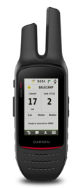
Take charge of your next adventure with BaseCamp™, software that lets you view and organize maps, waypoints, routes and tracks. This free trip-planning software even allows you to create Garmin Adventures that you can share with friends, family or fellow explorers. BaseCamp displays topographic map data on your computer screen, including contour lines and elevation profiles. It can also transfer an unlimited amount of satellite images to your device when paired with a BirdsEye Satellite Imagery subscription.
Turn Your Computer Into a BaseStation
Garmin BaseStation lets you turn your laptop (loaded with BaseCamp) into a field command center for tracking multiple Rino units. View real-time GPS information on the larger display of your computer while Rino serves as a router/antenna. And because it’s Garmin GPS-based, you're in control of more effective search and rescue operations, even when internet or cell phone service isn’t available.
Physical & Performance
- Physical dimensions 6.6 x 20.1 x 4.1 cm
- Display size, WxH 3.8 x 6.4 cm; diag 7.6 cm
- Display resolution, WxH 240 x 400 pixels
- Display type transflective, 65K color TFT
- Weight 348 g with battery pack
- Battery - removable, rechargeable lithium-ion battery pack; AA battery pack (not included)
- Battery life up to 14 hours (up to 18 hours with optional AA battery pack at 2 watts)
- Water rating IPX7
- High-sensitivity receiver
- Interface high-speed USB and NMEA 0183 compatible
- Barometric altimeter
- Electronic tilt-compensated 3-axis
- Transmit power 5 watts (UHF); up to 32 kms (LOS)
- Basemap
- Ability to add maps
- Built-in memory 1.7 GB
- Accepts data cards microSD™ card (not included)
- Waypoints/favorites/locations 10,000
- Routes 250
- Track log 20,000 points, 200 saved tracks
- Automatic routing (turn by turn routing on roads)
- Geocaching-friendly
- Hunt/fish calendar
- Sun and moon information
- Area calculation
- Picture viewer
- Frequency band UHF
- Channels 80 + 38 CTCSS
- Squelch codes 38 (CTCSS); 83 (DCS)
- Range - up to 32 kms (line of sight)
- VOX (voice activation)
- Location reporting (send and receive GPS positions)
- Vibration alert
- NOAA weather radio
- Contacts: 50
- Map segments: 15,000
- Active Weather support
- Bluetooth® ANT+® capable
- BirdsEye Satellite Imagery: not included