GPSMap 65s - $799
GPSMap 65 - $699
(Both units are in stock.)Mapping
These units comes preloaded with Garmin's TopoActive mapping. For New Zealand, the scale of this mapping is around 1:85,000.For an additional $100, Freshmap, at 1:50,000 scale, can be preloaded onto the unit leaving the microSD card slot available for other mapping eg nautical.
Click here for a TopoActive / Freshmap comparison.
Download a GPS65 v GPS64x series comparison.
Explore the World with Reliable Navigation in Hand
- Explore more with this rugged handheld that offers optimal tracking accuracy, a 2.6-inch colour display and preloaded maps.
- Don't miss a detail with this large, sunlight-readable colour display.
- Lead the way in challenging locations with multi-band technology and expanded GNSS satellite support.
- Cross the countryside with routable TopoActive maps.
- Venture confidently. This rugged handheld is built for tough environments.
- Organise your adventure from anywhere with the Garmin Explore website and app1.
- Travel with up to 16 hours of battery life in GPS mode.
Multi-band technology and expanded GNSS support (GPS, GLONASS, Galileo, QZSS (Japan) and IRNSS (India)) provide optimal accuracy in steep country, urban canyons and forests with dense trees.
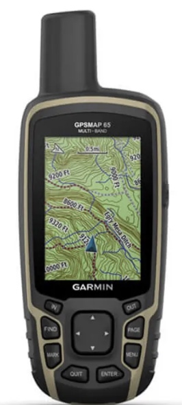
Preloaded TopoActive mapping
Preloaded TopoActive maps provide detailed views of routable street and off-road networks, waterways, natural features, land use areas, buildings and more.
Smart Notifications
Receive emails, texts and alerts right on your handheld when paired with your compatible device.
Geocaching
Get automatic cache updates from Geocaching Live, including descriptions, logs and hints.
Garmin Explore App
Plan, review and sync waypoints, routes and tracks by using the Garmin Explore app1 and website. You can even review completed activities while still in the field.
General
- Physical dimensions 6.1 x 16.0 x 3.6 cm
- Display size 3.6 x 5.5 cm; diagonal (6.6 cm)
- Display resolution 160 x 240 pixels
- Display type Transflective, 65K colour TFT
- Weight 217 g with batteries
- Battery type 2 AA batteries (not included); NiMH or Lithium recommended
- Battery life 16 hours
- Water rating IPX7
- High-sensitivity receiver
- Interface High-speed mini USB and NMEA 0183 compatible
- Memory/history 16 GB (user space varies based on included mapping)
- Preloaded maps Yes (TopoActive; routable)
- Ability to add maps
- Basemap
- Automatic routing (turn by turn routing on roads)
- Map segments 3,000
- Birdseye 250 BirdsEye Imagery files
- Includes some hydrographic features
- Includes some searchable points of interests
- External memory storage
- Waypoints/favorites/locations 5,000
- Tracks 200
- Track log 10,000 points, 200 saved tracks
- Routes 200, 250 points per route; 50 points auto routing
- GPS
- Glonass
- Galileo
- QZSS (Japan)
- IRNSS (India))
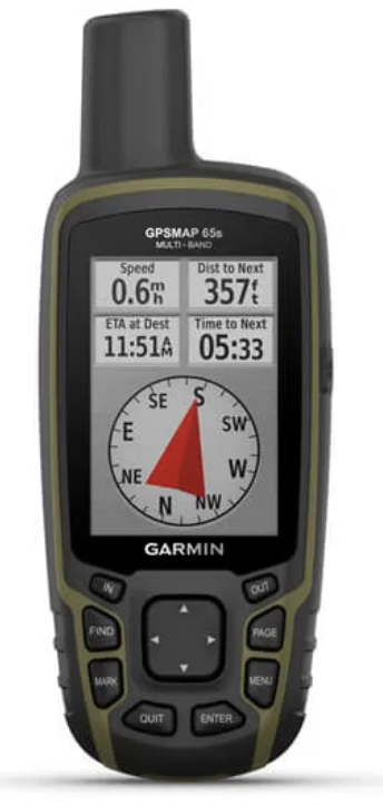
- GPS compass (while moving)
- barometric altimeter (GPS65s only)
- electronic compass (GPS65s only)
- VirbÛ remote
- Pairs with garmin connect mobile
- Smart notifications on handheld
- Point-to-point navigation
- Compatible with basecamp
- Area calculation
- Hunt/fish calendar
- Sun and moon information
- Geocaching-friendly
- Custom maps compatible
- Picture viewer
- Compatible with garmin explore app
- Garmin explore website compatible
- Wireless connectivity - BluetoothÛ, ANT+Û